6 Fascinating Ways Our Ancestors Navigated the Oceans
TLDRThis SciShow episode explores the ancient art of navigation before modern technology. It highlights six innovative methods used by different cultures, including the Marshall Islanders' stick charts, Arab sailors' kamal for latitude, the European cross staff and astrolabe, China's magnetic compass with Zheng He, and the Viking Sunstone. These tools demonstrate humanity's resourcefulness in mastering sea travel through celestial observation, understanding ocean currents, and utilizing the Earth's magnetic field.
Takeaways
- 📍 Nowadays, navigation is made easy by apps and GPS, but historically, getting lost at sea was a significant concern.
- 🌊 Before modern technology, sailors used various techniques to navigate based on the stars and ocean patterns.
- 🌟 The Sun and Polaris, the North Star, were crucial for early navigators to determine direction.
- 🗺️ Navigators from the Marshall Islands in Micronesia used stick charts to represent ocean swells and currents, which served as teaching tools for memorizing navigational knowledge.
- 🏝️ The Kamal, an ancient Arab device, was used to determine latitude by aligning it with Polaris and the horizon, with a knotted string to measure the angle.
- 🧭 The cross staff was an early European tool for measuring latitude, similar to the Kamal, but with a sliding crossbar on a marked staff.
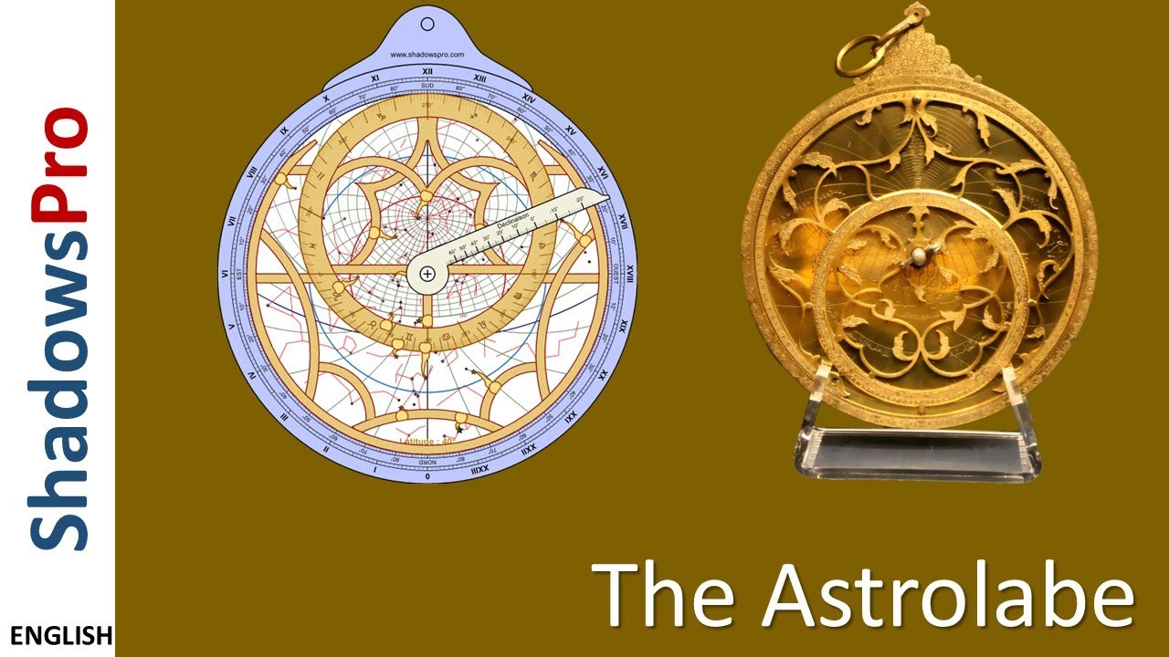
- ☀️ The astrolabe, an ancient Greek invention, was adapted for navigation by Portuguese sailors, allowing latitude measurement without a visible horizon.
- 🧭 Zheng He, a Chinese navigator, utilized the magnetic compass during his extensive voyages, which was one of China's significant inventions.
- 💎 The Sunstone, possibly made from Icelandic spar, was used by Vikings to determine the Sun's direction even when obscured by clouds, through the property of birefringence.
- 🛳️ The development and use of navigational tools like the Kamal, cross staff, and astrolabe, demonstrate the ingenuity of early sailors in overcoming the challenges of sea travel.
- 🌐 The script highlights the evolution of navigation techniques, showing how different cultures around the world independently developed methods to master the art of navigation.
Q & A
What is the main advantage of modern navigation apps compared to traditional methods?
-Modern navigation apps provide easy and accurate guidance no matter where you are, eliminating the risk of getting lost, which was a significant danger in the past, especially at sea.
How did ancient navigators compensate for the lack of technology at sea?
-Ancient navigators developed techniques to extract information from their surroundings, such as using the stars, particularly the Sun and Polaris, and creating devices to pinpoint their location based on celestial bodies and ocean currents.
What is unique about the navigation methods of the Marshall Islands in Micronesia?
-The navigators of the Marshall Islands used stick charts, which depicted ocean swells and currents with sticks or fibers, and small shells to mark islands, serving as teaching tools for memorizing ocean patterns before voyages.
What is the Kamal and how was it used by Arab explorers?
-The Kamal is a simple wooden device with a knotted string, used to determine latitude by aligning it with Polaris and the horizon while measuring the distance from the rectangle to the face with the string.
How does the angle between Polaris and the horizon relate to one's latitude?
-The angle varies depending on latitude; it is directly overhead at the North Pole and on the horizon at the equator, allowing sailors to estimate their latitude based on how close the rectangle is held to their face.
What is the cross staff and how does it measure latitude?
-The cross staff is a latitude-measuring device consisting of a long staff with degree markings and a sliding crossbar. It operates similarly to the Kamal by aligning the horizon with the bottom edge and celestial bodies with the top edge to determine latitude.
Why was the back staff developed as an alternative to the cross staff?
-The back staff was developed to avoid the issue of looking directly into the Sun, which was problematic with the cross staff. It allowed sailors to use shadows instead of direct sunlight for navigation.
What is the Mariners astrolabe and how does it differ from the Kamal and cross staff?
-The Mariners astrolabe is a heavy brass disc with a rotating arm, used to measure latitude based on the sun and stars without needing a horizon view. Unlike the Kamal and cross staff, it can be used in foggy conditions or when the horizon is not visible.
How did Zheng He's voyages in the 15th century utilize the magnetic compass?
-Zheng He's expeditions were among the earliest well-known voyages to use the magnetic compass for navigation, which had been perfected enough by the 15th century to guide his fleet across the ocean.
What is the Sunstone and how was it believed to aid Viking navigation?
-The Sunstone, possibly made of Icelandic spar or calcite, is believed to have been used by Vikings to determine the direction of the Sun through its birefringence property, even when the Sun was not visible.
Why might the Sunstone have been considered a myth for a long time?
-The Sunstone was considered a myth because, despite ancient Viking texts mentioning it, no physical evidence was found until a piece of Icelandic spar was discovered from a 16th-century English shipwreck, suggesting a possible Viking connection.
Outlines
🧭 Early Navigation Techniques and the Marshall Islands' Legacy
This paragraph delves into the history of navigation before modern technology, highlighting the challenges faced at sea and the ingenious methods developed by ancient mariners. The Marshall Islanders of Micronesia are spotlighted for their unique stick charts and profound knowledge of the stars, which served as their compass. These navigators could traverse the Pacific with just their understanding of celestial bodies and the ocean's currents. The stick charts, while not traditional maps, provided a tactile representation of the ocean's movements and were instrumental in teaching navigation skills. Despite the loss of much of this traditional knowledge, efforts are underway to revive these ancient navigation techniques.
🌐 Tools of the Trade: Kamal, Cross Staff, and Mariner's Astrolabe
The second paragraph introduces various navigational tools used historically to determine latitude and location at sea. The Kamal, a simple yet effective device used by Arab explorers, consisted of a wooden rectangle and a knotted string to measure the angle between Polaris and the horizon, thereby determining latitude. The cross staff, an adaptation used by European sailors from the 14th century, functioned similarly but was more convenient for use at sea. The Mariner's astrolabe, an evolution of these tools, allowed for latitude measurement without a clear horizon, making it useful in foggy or dark conditions. However, its use was fraught with inaccuracies due to the ship's movement. The paragraph also touches on the limitations and comparative advantages of these tools in different conditions.
🚢 Zheng He's Voyages and the Viking Sunstone Mystery
This paragraph explores the use of the magnetic compass in navigation, as exemplified by the voyages of the Chinese navigator Zheng He, who embarked on seven expeditions across the Indian Ocean and beyond with the support of the Ming Dynasty. The compass, initially used for divination, was refined for navigation by the time of Zheng He's first voyage in 1405. Additionally, the Viking Sunstone, once considered mythical, is discussed as a possible navigational aid that could determine the Sun's position even when obscured. Recent findings suggest that the Icelandic spar, a calcite crystal with birefringence properties, could have been the actual Sunstone used by Vikings for navigation.
🎨 Behind the Scenes: Acknowledging the Creative Efforts
The final paragraph steps away from the historical narrative to acknowledge the creative team behind the video, particularly the animators whose hard work is recognized and appreciated. The speaker invites the animator to add their name to the episode for proper credit, highlighting the collaborative effort that goes into producing such content.
Mindmap
Keywords
💡Navigation App
💡GPS
💡Marshall Islands Navigators
💡Stick Charts
💡Kamal
💡Latitude
💡Cross Staff
💡Astrolabe
💡Magnetic Compass
💡Sunstone
Highlights
Modern navigation apps make it easy to find your way, but historically, getting lost at sea was a real danger.
Early navigators used the stars, especially the Sun and Polaris, to determine direction without modern technology.
People around the world developed unique techniques to extract information from their environment for navigation.
Navigators in the Marshall Islands used stick charts to represent ocean swells and currents, aiding in their voyages.
Stick charts were teaching tools, with navigators memorizing the information before setting out.
The Kamal, a simple wooden device with a knotted string, allowed Arab sailors to determine their latitude.
The angle between Polaris and the horizon, measured with a Kamal, indicates one's latitude.
The cross staff, used by European sailors, was a latitude-measuring device similar to the Kamal.
The astrolabe, an ancient Greek invention, was adapted for maritime navigation to measure latitude without a horizon view.
Chinese navigator Zheng He used the magnetic compass for his extensive voyages in the 15th century.
The Sunstone, a Viking navigational tool, could determine the Sun's direction even when obscured by clouds.
Icelandic spar, a calcite crystal, is believed to be the Sunstone used by Vikings for navigation.
The use of Sunstones was thought to be a myth until recent experiments confirmed their navigational potential.
Despite the availability of advanced tools, some sailors preferred simpler devices due to ease of use and accuracy.
Traditional knowledge of navigation has been lost over time, but efforts are being made to revive these ancient arts.
The episode of SciShow explores various historical navigation methods and their impact on human exploration.
Transcripts
Browse More Related Video

AP World History Modern: AMSCO - 4.1 Read Aloud

Tom Wujec - Anatomy of the Astrolabe

TECHNOLOGY in Sea-Based Empires [AP World History Review—Unit 4 Topic 1]
Introduction to astrolabes: history, design and how they work.

Lenz's Law

Technological Innovations in Sea-Based Empires [AP World History] Unit 4 Topic 1
5.0 / 5 (0 votes)
Thanks for rating: